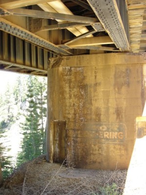
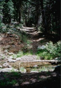
Cascade Ravine today: "No Loitering"
 |
 |
Bridge abutment with sign
The warning is old and faded. You can barely make out the words, "NO LOITERING." Looking around in this shady place under an old railroad bridge high in the Sierra, you might wonder who would be drawn to this dreary spot--let alone loiter.
Trails and Rail Beds
A narrow ridge sloping west from Summit Valley separates the North Fork of the American River from the South Fork of the Yuba River. About six miles west of Donner Pass a lake now called Cascade drains into a seasonal creek which empties into the Yuba.
|
In the 1840's westbound wagon parties followed the ridge to the lake and angled north crossing the creek and proceeded into Yuba Canyon. In the 1860s builders of the Central Pacific Railroad carved a ledge into the granitic Yuba side of the ridge and laid a bridge across Cascade's creek. During the past 150 years, the ravine in which Cascade Creek once flowed has seen its share of troubles. Where once emigrants perished in early winter, dirt bikes now roar down footpaths and clatter across the rail bridge. |
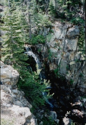 Cascade Falls 1994 |
A Walk from Cascade Lake to the Railroad Bridge
(for adults only)
|
Remnants of the old emigrant trail skirt the northeast corner of Cascade Lake and lead to a fording place across the creek. |
 Ford |
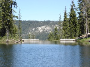 New Dam |
Below this fording place a natural pond once interrupted the flow of the creek before it spilled as a waterfall down the ravine. Recent dam construction has reduced the creek's flow to a trickle. |
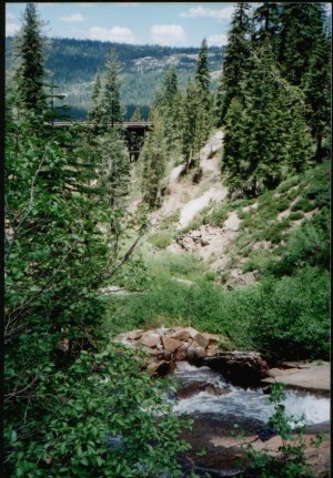 View of RR Bridge from Emigrant Ford |
From the ford the emigrant trail followed gentler terrain before descending northwest to the South Yuba River. Physical evidence of the precise route disappeared years ago. However, present day explorers can follow a path along the west cliff of the ravine to view and embrace the next stage of history: the railroad bridge at "Cascade Station" on the Transcontinental Railroad. |
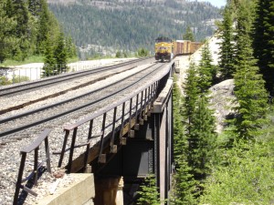
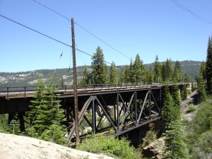 Railroad Bridge |
A pathway through the rocks leads down the bank and under the bridge to its westerly abutments. Here is where the six-foot high banner painted on concrete warns: "No Loitering"! |
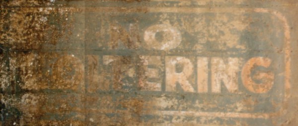
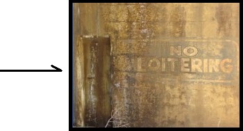
Sign Closeup
The question remains, who in earlier days would have loitered here? No road leads to the sign. It faces directly into the side of the ravine and is visible only from under the bridge. The letters are very faded. When might it have been painted?
 California Zephyr |
Standing before the sign you might hear an air horn and watch the approach of a locomotive--perhaps the California Zephyr creeping towards the bridge. The host from the California State Railroad Museum sits in the lounge car telling stories of the high Sierra. Ten years ago they might have seen a waterfall. Today they see only glimpses of water. |
The Forlorn Hope: Ghosts of the Truckee Emigrant Trail, 1840s
In the winter of 1846 exceptionally heavy snowfall filled the ravine. A party of emigrants struggled to cross it. They were the so-called "Forlorn Hope," fifteen members of the Donner Party who attempted to escape from the Sierra. They suffered greatly along this stretch of their journey. Their testimony refers to storms and terrain where they languished for days without fire or food. Charles Stanton, sitting alone smoking his pipe, said goodbye to his companions and froze to death. Until recently a grave marker sat along the emigrant trail at near the place where the trail left the lake and entered the ravine. [Ref 1] The diary of Mrs. Foster tells how she watched the heat of their campfire melt a deep pit in the snow:
"A huge fire was kindled....the heat...thawed the snow [forming] a deep well-like cavity...[which] gave way and the fire disappeared....[they] peered over the brink [and heard] far down in the gloom...the sound of running waters."[Ref 2 ]
Early maps dating from 1866 show the emigrant trail crossing Cascade canyon. [Ref 3 ]
1866 survey map 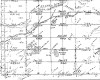 1897 survey map
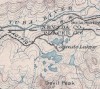
Trail historian, Charles Graydon, mentioned an emigrant trail from Lower Cascade Lake fording the creek, crossing the railroad and then proceeding northwest to a point west of Donner Trail School on the South Yuba.[Ref 4 ]
South Yuba Water Development, 1850s
Cascade Lake began as a natural lake, the result of glacial and tectonic forces. Its outfall flowed through the geologic contact where rhyolite on the east side of the ravine met granodiorite of the west side. [Ref 5 ]
Geologic Map 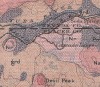
The lake was first named during the gold rush when it was mined, not for gold, but for water-- essential to the mining industry. It was called by many different names in the early days.[Ref 6 ] It was dammed in the late 1850s to enhance the storage capacity of the South Yuba watershed.[Ref 7 ] The South Yuba Canal was constructed about that time to divert South Yuba water to the Bear River.[Ref 8 ] The South Yuba Canal Company incorporated in 1870, consolidating earlier canal companies.[Ref 9 ] It became the South Yuba Water and Mining Company under new ownership in 1880.7 It served hydraulic mining interests until the Sawyer Decision of 1884 curtailed such mining by forbidding disposal of untreated mining debris. The company deleted 'mining' from its name. It was not long before the reservoirs and canals on the South Yuba were harnessed to generate electric power. By 1892 a power plant had been built on the South Yuba by the Nevada Electric Power Company. It formed the nucleus of what became PG&E which now owns and manages Cascade Lake.
Central Pacific Railroad (CPRR), 1860s
It is remarkable that less than fifteen years after the first wagon parties struggled over the trail, Theodore Judah proposed to route a section of the transcontinental railroad across the same terrain. Judah's maps and reports mention the existing South Yuba "ditch," "Kidd's Reservoir," and the "Old Truckee Emigrant Trail" as well as the natural obstacles to transportation presented by the South Yuba canyon and the steep-sided ridge above its south side. He remarked on the odd relationship of the South Yuba to the Bear River and believed the Yuba had once flowed into the Bear. He had to abandon his chosen route up the South Yuba to Summit Valley when he realized the gradient was too steep.8 He was forced to hack and blast a ledge for a rail bed out of the granite and volcanic rocks of the steep ridge above the South Yuba. This decision required spanning ravines such as Cascade with bridges.
Construction of the CPRR began in Sacramento in 1863. By the end of 1867 trains ran to Cisco and most tunnels in the high Sierra had been completed. Eighteen-foot lengths of redwood lumber were split by whip sawing and shipped by rail and then hauled by sleigh to staging areas where they were left until October. The difficult seven-mile stretch along the steep side hill ledge, which included Cascade ravine, remained incomplete. The actual bridge building was planned for October and November before the winter storms commenced.[Ref 10 ] Construction ceased in late October and resumed early April.[Ref 11 ]
A 204-foot Burr type truss span was constructed across Cascade ravine. It incorporated a wooden arch and trestle approaches anchored on stone piers.[Ref 12 ] The work was carried out over the winter of 1867-68 and completed April 3, 1868. Passenger and freight service to Truckee commenced June 18 that year.[Ref 13 ]
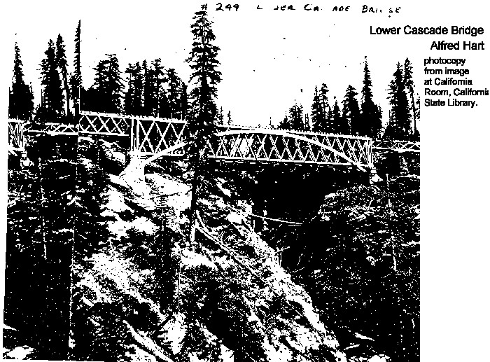
Scheduling and specifications for the original bridge construction was guided mainly by one principle: do not delay the opening of the railroad. This criteria did not provide a permanent solution to ravine crossings. The trestles were soon replaced. The Alfred Hart photo shows debris of a trestle below a replacement bridge at Cascade.[Ref 14 ]
Below is a photocopy of the Alfred Hart photo of Lower Cascade Bridge--undated. It is copied from the California State Railroad Museum library.[Alfred Hart #5557]
A most dramatic incident occurred at Cascade when locomotive #210 slid backwards from Summit and crashed through the station and into the canyon.[Ref 15 ]
As originally built, the section of railway between Blue Canyon and Truckee contained only a single set of tracks. Various strategies were devised to ensure the safety of two-way traffic on one-way tracks. It was clear from the beginning that double sets of track would soon be required.
In the early twentieth century when Union Pacific sought to take over Southern Pacific (which then included the Central Pacific), it commenced the process of converting the old single-track railroad to double track. Meanwhile the federal government had brought an antitrust suit against the Union Pacific merger. This stopped the improvements until 1923 when the Interstate Commerce Commission ruled in favor of SP's request to improve the section from Blue Canyon to Truckee. A steel viaduct was built across Cascade ravine in in 1925.[Ref 16 ]
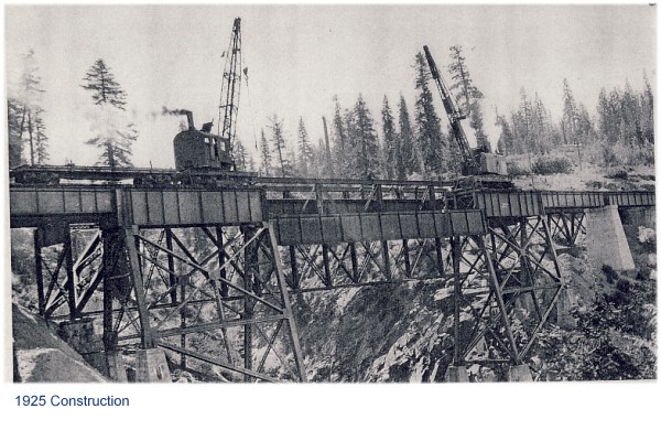
1925 Construction at Cascade
SP Lower Cascade, Troy, September, 1925 (Construction scene postcards).[Ref 17 ]
Concrete piers were built at Cascade in 1930 on foundations dating back to 1895. New concrete abutments were installed at that time.[Ref 18 ] Therefore the "no loitering" sign dates after 1930. The open deck of the bridge was replaced with a ballast deck in 1941. The bridge was damaged by fire September 8, 1944.
1944 Fire at Cascade 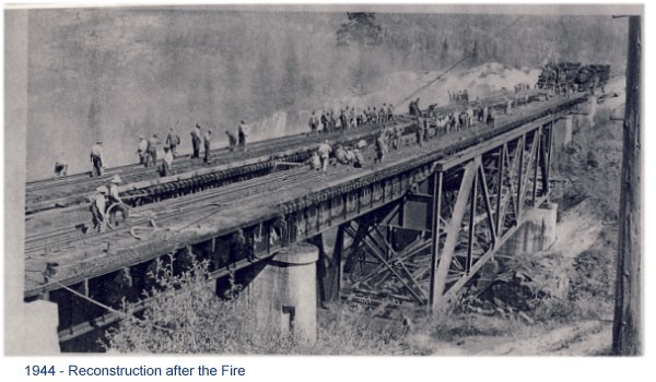 [Ref 19 ]
SP Lower Cascade, Troy, (after fire September 8, 1944
A bridge inspection report notes some part of the bridge was painted in 1946. The report, however, does not mention if the paint was applied to a sign warning, "No Loitering." One wonders, what other reason?
Present Day Bridge
Originally snow sheds were built over all railroad track in the high Sierra not protected by tunnels. Sheds built at Cascade in 1868, burned in the summer of 1889, and then were rebuilt. In the process of making improvements during the twentieth century, snow sheds were torn down and many were not replaced. By then locomotives with snow removal capability were used to remove snow from tracks. Unfortunately they were unable to deal with the heavy snowfall of January 1952. The City of San Francisco Streamliner became snowbound two and one half miles west of Cascade, causing a notorious rail catastrophe.
Recreation at Cascade
All kinds of recreation are available in the vicinity of Cascade Lake. For at least 200 years settlers and bushwackers have relished exploring the high Sierra. By the end of the nineteenth century winter sports activities had penetrated the wilderness. In the late 1960s a ski and snow play area called "Play-Vada" was established just below the Cascade Bridge.

|

|
Remains of poma lifts
Now the area accommodates not only cross country ski trails from Royal Gorge but also a horse camp. Cascade Lake continues to store water for PG& E and the South Yuba watershed. The lake features fishing and hiking in the summer but no motorized water craft are permitted on the lake. It is known as the gateway to the Palisade Trail which descends to the North Fork of the American River.
Cascade Lake 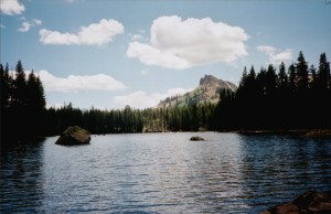
References Cited:
1. C.F. McGlashan, History of the Donner Party (Truckee, CA: Crowley & McGlashan, 1879) p. 59: "In May 1847 W.C. Graves in company with a relief party found the remains of C.T. Stanton near the spot where he had been left by his companions." Charles Graydon and Nevada County Sheriff's Explorer Scouts placed a trail marker in 1983 [Susan Wolbarst, "Emigrant Trail," Grass Valley Union, October 4, 1983]. According to Carrie Smith, Archeologist, Tahoe National Forest, the Forest Service replaced the marker in 1988 but it has since disappeared.
2. C. F. McGlashan, History of the Donner Party, p. 65.
3. Maps produced in the 1860s reveal such a trail. The1866 General Land Office survey shows a trail crossing a ford in the Lower Cascade canyon. The 1897 U.S.G.S. topographical map shows a similar crossing.
4. Charles Graydon, Trails of the First Wagons over the Sierra Nevada (Arizona: Patrice Press, 1986), p. 55.
5. Waldemar Lindgren, Historical Geology - northwest, Folio #39, Truckee, CA, Geologic Atlas of the United States, United States Geological Survey, 1897, Map collection, Sacramento Room, Sacramento Central Library, reproduced at
6. An 1870 quitclaim to the South Yuba Canal Company refers to it as one of the Devil's Peak Lakes, named for the adjacent 7700 foot peak. The 1880 Nevada County Map refers to what is now Cascade Lake as Kidd's Lake and what is now Kidd Lake, as Devil's Peak Lake.
7. Dale Johnson, email correspondence to author, Feb. 18, 2005. Reservoir and water rights located May 1856 by D.A. Rich according to affidavit of James Whartenby, Feb. 3, 1880, documenting properties of the South Yuba Canal Co. prior to sale to South Yuba Water and Mining Company.
8. P.M. Downing, Chief Engineer Hydro-Electric Department, "The South Yuba-Bear River Development as Completed to Date, Pacific Service Magazine, Vol. 9, No. 1, June 1917, p. 3. 9. James Whartenby, et al to South Yuba Canal Company, quit claim, Nevada County Recorder, Deed Book 36, p. 161.
10. Dale Johnson, PG&E, Retired, "The Nevada Rome Powerhouse and the Birth of PG&E," See at See at Railroad Museum web site. "The ridge between Bear Valley and North Fork of American River is about 800 feet high. Here occurs a singular freak of nature. The South Yuba, augmented by numerous large branches along its course, is seen emerging from impassable rocky canons, and, sweeping down through the head of Bear Valley, it turns suddenly to the north and pierces the ridge or divide lying north of Bear valley, forcing its way out to the northward between rocky walls surmounted by peaks from 2,000 to 3,000 feet high."
12. George Kraus, High Road to Promontory, (Palo Alto, CA: American West Publishing Co., 1969), p. 163. Quoting A.P. Partridge, member of Arthur Brown bridge building crew. 10 Dutch Flat Enquirer, 30 October 1867 quoting Virginia Territorial Enterprise 26 October; 11 April 1868 quoting Nevada [City] Gazette.
13. Historic American Engineering Record [HAER No. CA-1961] See atRailroad Museum web site National Park Service, Western Region, Dept. Of the Interior, San Francisco, CA 94107
14. Dutch Flat Enquirer carried the CPRR schedules which advertised service from Sacramento to Cisco up until 20 June and service from Sacramento to Reno from 27 June.
15. Alfred Hart: R.A, California State Museum, Photo ID 5557.
16. Signor, p. 69. Cascade was a station in the early days. An 1893 timetable shown in Kraus, p. 280-281 shows it as a flag stop.
17. HAER Report (Ref 13)
18. CA State Railroad Museum, Sacramento
19. SP Bridge Inspection Reports, 1956, California State Railroad Museum, pp. 235, 236.
[top] [Forlorn Hope] [South Yuba Canal Co.] [Central Pacific Railroad]